


Description
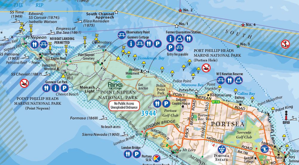
Explore the Mornington Peninsula like never before with this fully detailed and beautifully presented map. Featuring postcode boundaries, the peninsula’s hills and valleys in relief, and an up-to-date road network with subdivisions, it’s designed to help you navigate every corner with ease. This fully revised 3rd edition includes tourist attractions, wineries, distilleries, local produce farms, parks, golf courses, and recreation reserves, all with handy contact tables. New symbols highlight buoys, channels, and navigation aids, while the 1:50,000 scale ensures maximum detail for every journey. Perfect for businesses, tour operators, real estate agents, accommodation owners, holidaymakers, and locals, the map is as versatile as it is practical. Display it as a large, eye-catching wall map (855mm x 1122mm) or fold it down to a convenient glove box size (285mm x 187mm) for on-the-go adventures. Whether you’re exploring scenic highways, hidden byways, or planning your next getaway, this map is an indispensable companion for anyone who lives, works, or plays on the Mornington Peninsula.


Craig –
The level of detail is fantastic. Amazing the things we didn’t know that were highlighted on the map on the Mornington Peninsula. Perfect for framing and will look great in my study.