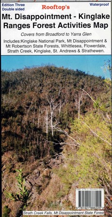
Description
Rooftop Map at 1:50,000 scale covering Reedy Creek, Wandong, Upper Plenty, Mount Disappointment, Hazeldene, Flowerdale, Strath Creek Falls, No.1 Camp, Blair’s Hut etc.
Facility symbols include Camping Areas, Picnic Areas, Lookouts and Fishing Spots.
The map also includes, roads, vehicle, motorcycle and walking tracks, contours, elevations, and GPS co-ordinates with an inset of the Strath Creek falls area.
Also Featuring Kinglake National Park
Coverage includes Kinglake West, East & Central; Steels Creek, Strathewen, Pheasant Creek, Masons Falls, Mt Jerusalem, Mount Robertson, West Bridge, Wombelano.
Waterproof, tear-resistant, pocket-size.

Reviews
There are no reviews yet.