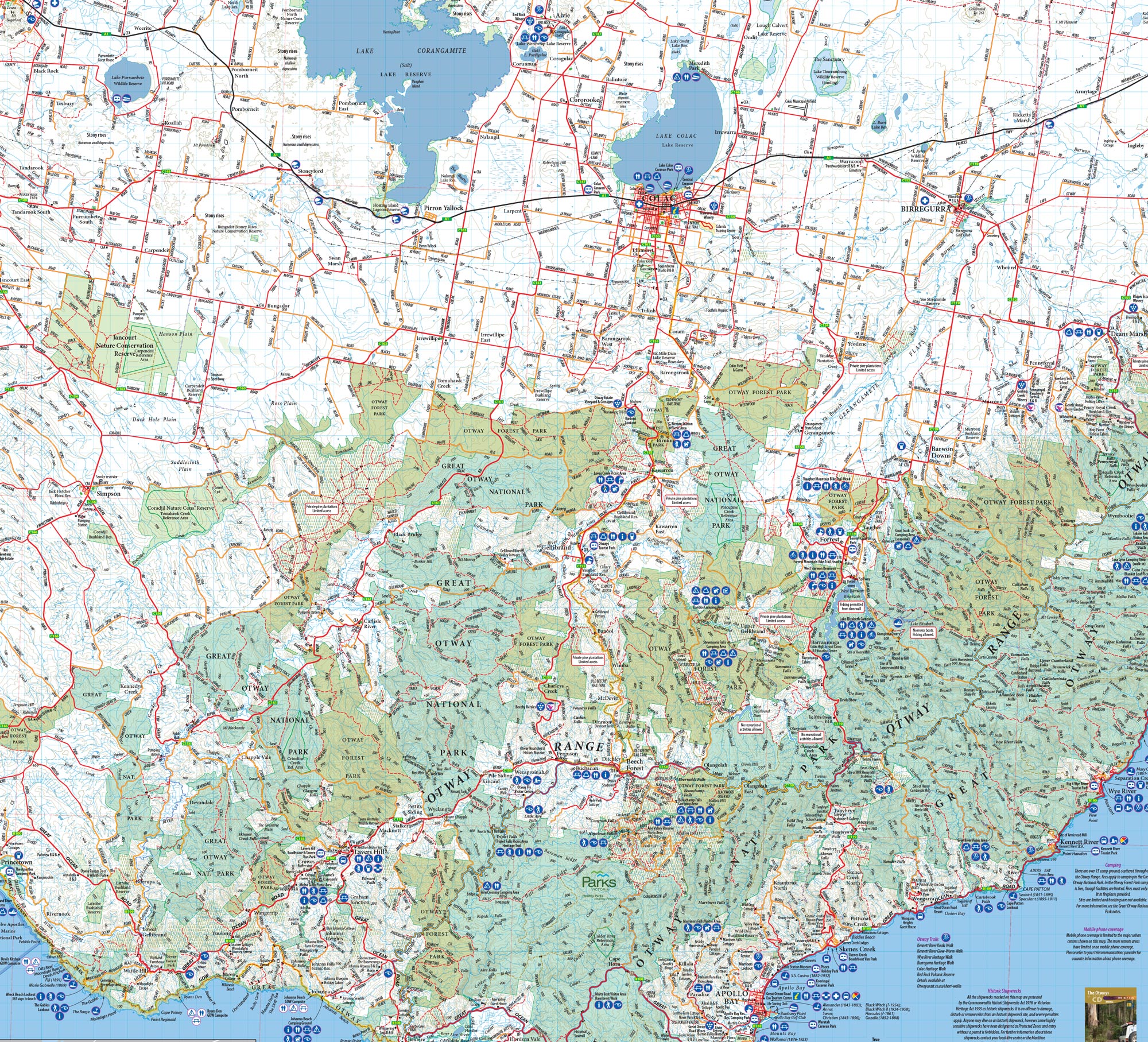
Description
This double sided Otways 4WD Map is a high-quality, detailed resource specifically designed for 4WD enthusiasts and outdoor adventurers to explore the rugged terrain of the Otways region. This map provides extensive coverage of the Otways, including the Great Otway National Park, Otway Forest Park, and Otway Drive. It features detailed topographic and contour lines, information on 4WD tracks, fire trails, campsites and points of interest. Whether you’re a seasoned 4WD enthusiast or a first-time visitor, this map will help you plan your route, find campsites and other points of interest, and make the most of your adventure in the Otways region. It is printed on durable paper, designed for easy reading and interpretation. Available in Print, digitally and in the Victorian 4WD Map Pack.
Key Features:
• New scale of 1:75,000
• Side 1 – Anglesea to Apollo Bay
• Side 2 – Apollo Bay to Princetown
• Detailed 4WD Tracks
• Walking tracks including; Great Ocean Walk, Surf Coast Walk & Old Beechy Trail
• Tourist, history, caravan and camping information
Notes
Stevensons Falls Campground is closed over the summer of 2022-2023 for the creation of a safer and more accessible visitor experience. The upgrades will be accessible for people of all abilities, with the construction of a wheelchair-accessible waterfall viewing platform, the widening of a pedestrian walkway to the platform and new disabled parking. A new wheelchair accessible toilet block will also be installed at the picnic area. There will be a new viewing platform at the ground level that will extend three metres out over the river. Seating on the platform will provide space for visitors to relax and enjoy the sights of the spectacular falls. The walk between Stevensons Falls and the arrival area will also be upgraded, with resurfacing and widening of sections. The upgrade will include the installation of a new boardwalk that meanders through a plantation of Red Woods, across the Gellibrand River and along the riverbank. Downstream from Stevensons Falls, a dedicated picnic area will be built alongside the Gellibrand River and will include new picnic tables and additional seating. The current carpark will be removed, and a larger carpark will be built at the arrival area, including all abilities and minibus parking spaces. Access to Upper Gellibrand Road will be restricted to local residents only while construction activity is underway.


Alistair –
Best map of the Otways– without doubt!
Brett –
This map is fantastic. There is so much to see and do in the Otways and the detail of this map is excellent. I have called Meridian Maps a few times and they have always been exceptionally helpful. Great maps and great customer service. Highly recommend!
Nicholas –
A great Map, plenty of detail even of the more out of the way/remote localities. The map is printed a substantial grade paper so it will undoubtedly be farely durable. The detail is quite clear and easy to read. I’m quite happy with it; thanks.