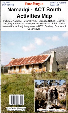
Description
Explore Namadgi National park with this 1:50,00 contoured map, which is ideal for bushwalking.
Coverage includes Namadgi National Park, Tidbinbilla Nature Reserve, Googong Foreshores, small sections of Kosciuszko and Brindabella National Parks & adjoining areas in New South Wales, Southern Canberra and Queanbeyan. Bimberi Wilderness.
Includes photos of the Bush Huts of Tidbinbilla and Namadgi Parks.
Huts included:
Frank and Jacks Hut, Horse Gully Hut, Pryors Hut, ACT Forests Hut, Demandering Hut, Max and Burts Hut, Rock Valley Homestaed, Mt Frankling Shelter, Cotter Hut, Nil Desperandum Homestead, Bushfolf Flats Hut, Hospital Creek Hut, Lutons Crutching Shed, Brayshaws Hut, Brandy Flat Hut, Orroral Homestead, Bendora Hut.
SOME HUTS MAYBE CLOSED PLEASE CHECK WITH PARKS BEFORE GOING
Detail includes roads, tracks, walking tracks, watercourses, bush huts, contours.
Laminated version also available.

Reviews
There are no reviews yet.