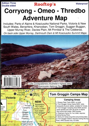
Description
This Rooftop map covers Corryong, Khancoban, Nariel, Gibbo, Pinninbar, Tom Groggin, Benambra, Omeo, Taylors Crossing, Glen Dart, The Cobberas, Cowombat Flat, Suggan Buggan, Wulgulmerang, Davies Plain, Upper Murray and Thredbo. and parts of the Alpine National Park, Kosciuszko National Park and Upper Murray River.
All parks, reserves and state forests are shown and all roads and tracks within the map area have been plotted using GPS mapping technology.
The reverse side features inset maps of Dartmouth Dam, Upper Murray and Mount Kosciuszko Summit Access.
Printed on waterproof paper.


Reviews
There are no reviews yet.