Description
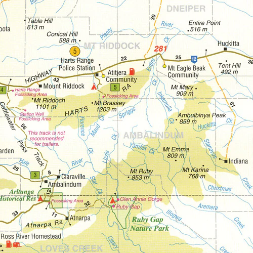
The Plenty & Sandover Highways provide the most direct access from Alice Springs to Boulia, Mt. Isa and other parts of western Queensland. These roads are far more interesting ways to reach The Alice or Mt Isa than the bitumen alternatives. They also lead the traveller through interesting places that might well have remained unexplored dots on the map. These include Fossicking near Gemtree, Boxhole Meteorite Crater and the Aboriginal community of Atitjere where you can buy some of the local art. You cross a range of landscapes from spinifex plains to mulga woodlands and the channel country of western Queensland.
A feature of all Westprint maps is the amount of text of historic and tourist interest. The map contains numbered symbols cross-referenced to detailed information on each numbered site. Intermediate and major distances are clearly shown and there are symbols for fuel locations, rest areas, caravan parks and camp sites. Early explorers routes have been colour-coded. There are also GPS co-ordinates.
This map covers: Plenty Highway, Sandover Highway, Eyre and Diamantina Developmental Roads, Birdsville, Boulia, Dajarra, Alice Springs and Mt Isa.
Key Features
• Detailed 4WD tracks
• National parks
• Specific 4WD, caravan and camping information
• GPS surveyed roads & tracks
• Heritage & tourist information
Reviews
There are no reviews yet.